, , ,

March for Science North Pole Edition

Nobody should argue the sense of science. Science is to celebrate our brilliant minds everywhere in the world. Those who seek to understand the complexities of our planet, those who have inquisitive minds and are driven by a curiosity for knowledge. Scientists can help us move forward into solving our climate crisis that we ourselves have created. Climate change is one of the most challenging topics of science- we humans have never experienced it before. It is a moving target and  we need to get all the geniuses together to mitigate the consequences of climate change - the biggest threat to our planet.

Scientists have not been comfortable to express an opinion about climate change in the last decades. Afraid of losing funding or face in front of peers. Most have stick to facts and models not to be pushed into statements or premature conclusions. But recently climate scientists have been categorized into radicals or climate deniers if they see climate change as a reality, polarized into believers and deniers. Often unfairly cornered by media, politics and even businesses, scientists are losing objectivity - the very foundation of science.

Science is not about believing, science is about methods, relativity, models, statistically relevance, track records and sampling and more models and sampling.
Science is about objectivity but passionate scientists or those who want to warn the world are considered alarmists. Record-breaking global temperatures and unprecedented attacks on government scientists and an administration that appears unwilling to accept—nevermind act on—well-established scientific facts.
Science, evidence, facts, and reason form the very foundation of a strong democracy—and they are under scrutinized like never before.

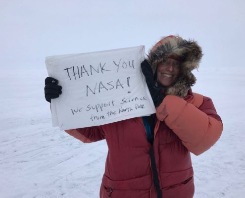
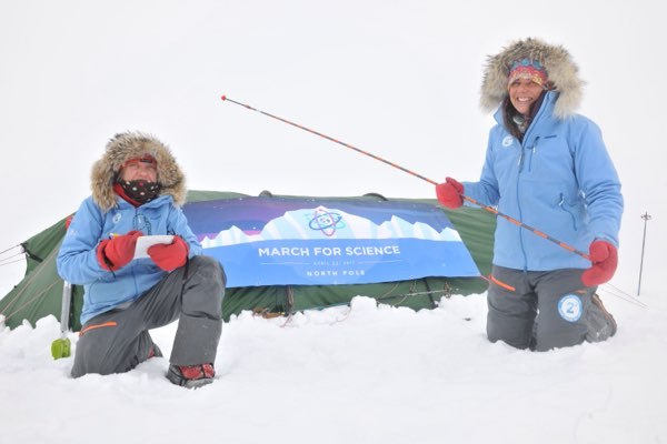
During the last three weeks I have supported scientists by marching to the North Pole, an extreme expedition of 224 km facing -40°C temperatures while still collecting data on the ice to support NASA/ESA and arctic scientists.
Our mission was a simple one: collecting snow measurements along a transact to be flown over by NASA Icebridge on April 6th.
This invaluable data is so desperately needed to understand ice thickness in relationship to snow.
Without this kind of knowledge of data, it would be hard to validate the snow radar in the Icebridge airplane and to understand the overall ice thickness which will have implications on the maximum extent and predictions of the health of the arctic and the world’s climate.

The importance of science in the Arctic is evident- we need not to discuss its value and its merit we need to support it and allow more of our resources. Arctic science is the enigma, the most important one of all climate science.  The Arctic is the poster child of climate change - it is here were the changes are happening the fastest.

So we flew our banner of March for Science two days ago at the North Pole and we are joining tomorrow at UNIS here in Longyearbyen for the March of Science in Svalbard.

, ,

NASA overflight happened today!

Today was a great demonstration of total collaboration between many parties all wanting to achieve the same objective; measuring the arctic sea ice.
When Martin and I got invited to an ESA meeting in January we met Nathan of NASA who told us about the Icebridge campaign and their new flight route over Svalbard in the spring.
Their objective is to get a better understanding of the Eastern Arctic, something they haven’t been able to do.
We compared our routes and we quickly decided that NASA should do a flyover over our route to the North Pole.
Many emails, coordination and planning went into this.

Icebridge is coming from Thule Greenland and flew over the icecap measuring ice, snow, temperature en route to Svalbard.
First it appeared NASA was going to be a lot earlier then our planned drop-off but then we got delayed by 4 days and risked to miss NASA all together.
Luckily, as if this important mission was serendipitous, today at 3:30 pm the Icebridge P3 plane flew right over us the coordinates perfectly communicated.
Even a minute of latitude to the east or west, there is the chance of missing us completely on this immense Arctic Ocean.

Back in Svalbard is Kyle - engineer but much more really: a genius with GPS and a neck for coordination.
Our Iridium Rock Star sends GPS coordinates every 15 minutes to NASA.
Kyle compiles them and put them in a document for John Sonntag who instructs the pilots where to go and Nathan who is the project manager keeps an eye out for us from his big window in the plane.
John Woods had given us buoys to deploy when we got dropped off with the helicopter to mark a starting point and one to leave on the day of the fly over.

Just following our GPS coordinates would not be enough since we move and the ice drifts.
Flooded with data  and everybody’s participation, this morning at 7 am we heard to news of the planned flyover for today coming from Henk-Jan our Basecamp manager.
The plane flew first to the North Pole and 30  minutes later we heard the loud engines and saw the contrails aiming right for us.

Martin filmed from below, Jefferson from the plane and the instruments are working hard to process our data.

Why does this matter?
Each day we are doing 50 measurements - 2 km apart to understand the snow depth on the ice.
By flying over us, Icebridge can calibrate our coordinates on the ice with the coordinates they measured and to get a ground check of the snow we measure each day versus the measurements they get from the snow radar on the plane.
In a few weeks we give them our 1250 measurements and plot them against their flight path ( our trek) and examine if the data is consistent.
This was a real highlight and we feel honored to have work with Icebridge,
Thanks Nathan, John, Kyle and Henk-Jan for making this happen today.

, ,

OIB completed the high priority Svalbard North mission.

OIB completed the high priority Svalbard North mission.
This mission was designed to sample sea ice on the eastern hemisphere side of the Pole, within the Russian FIR boundary which had formerly been off limits to OIB.
A portion of the return leg to Longyearbyen was along an ICESat-2 ground track.
In addition to Level 1 Requirements SI1 and SI2, this mission addresses sea ice level 1 baseline requirement SI3d by sampling sea ice in the eastern Arctic.
We also coordinated an overflight with the 2Dgrees expedition party, they arrived on the sea ice on April 4 at 88N latitude and 150E longitude and are taking snow depth measurements on their way to the North Pole along a portion of our flight track.
We passed directly over the expedition party at 13:16:05Z and saw them in the DMS, CAMBOT, and FLIR images.

Deze diashow vereist JavaScript.


The weather forecast for the mission showed mainly clear skies with some clouds on the southern portion of the line near Svalbard and haze near the eastern most end of the line.
Haze was indeed present along the southern portion of the line on both the outbound and return legs, and there was also some near the North Pole.
But the haze was thin enough for all instruments to see through and collect good data for most of the mission, with about 15 minutes of ATM data lost on the southern portion of the line due to clouds.

ATM CAMBOT visible image of 2Dgrees team. (NASA/Robbie Russell)

Follow Icebridge on Facebook

1250 sneeuw metingen

De afgelopen dagen was ik op een conferentie in Banff met wetenschappers van de ESA en NASA.

De conferentie ging over de CryoSat satelliet en de arctische campagnes die wetenschappers komende maanden uitvoeren.

Verschillende Universiteiten bundelen hun kennis en financiële middelen om de satellieten te kunnen afstellen met metingen op het ijs.

Deze ingewikkelde logistiek zorgde voor vele drama’s in de wandelgangen.

Spullen die naar Groenland  gestuurd zijn maar nu naar IJsland moeten of kosten die 3x meer zijn dan begroot.

Dit alles resulteerde in nog meer samenwerken en kortere vliegtijden.

Het zijn dus niet alleen de poolreizigers die de hoge transport kosten niet meer kunnen betalen, ook wetenschappers lijken voor hetzelfde blok te staan.

Andrew Sheppard van de Universiteit van Leeds gaf een somber beeld over de ijsdikte in het Arctisch gebied op dit moment.

Er is bijna geen ijs in Rusland (start van onze expeditie) en veel ijs in Canada.

Voor het accuraat meten van ijs moet je ook weten hoeveel sneeuw erop het ijs ligt en dan doen de flyovers van ESA en NASA in de komende maand.

Flyovers in Groenland, Canada en Svalbard.

De laatste van NASA vliegt boven ons in April.

Met radar technology meten ze de rand van het ijs en weten ze door het oppervlak te meten hoeveel sneeuw erop ligt.

In bijgevoegd plaatje zie je dat weinig sneeuw (0cm) gepaard gaat met weinig ijs en andersom.

Toeval?